The Historic Round Rock Collection is a project documenting Round Rock’s history, funded in part with a grant from the Texas Historical Commission. These pages are adapted from the original 1991 print version.
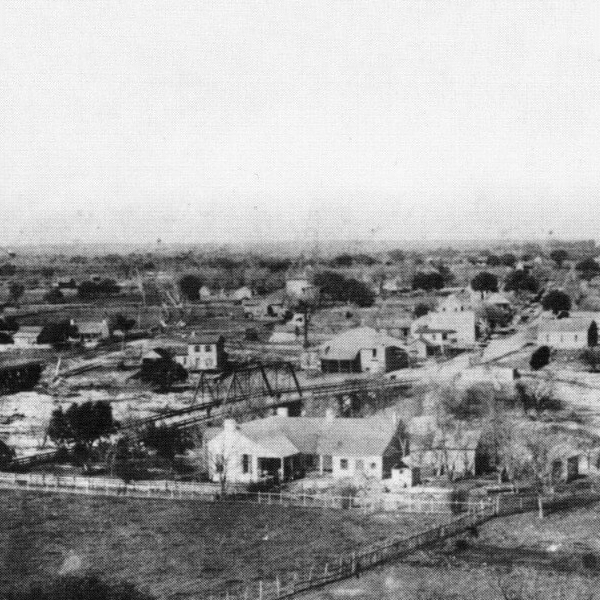
The coming of the railroad in 1876 forced the town of Round Rock to relocate in order to survive. Old Town remained after New Town was constructed but its importance declined, and it was not until recently that reinvestment occurred in Old Town. New Town has remained a viable business district up to the current time, and its historic flavor has been emphasized by its designation as a commercial historic district.
On May 6, 1876, a Round Rock citizen, Washington Anderson, sold 150 acres of land to the International and Great Northern Railroad for $3,000. The Railroad kept 25 acres for use as its right-of-way; the remaining land was then sold to the Texas Land Company (a subsidiary of the International and Great Northern Railroad). The Texas Land Company then divided the land into 46 blocks of lots and announced that the land was for sale (DiGesualdo and Thompson 69-75). Washington Anderson hoped that the newly platted town would be named Andersonville in his honor; however, the name Round Rock was retained with this new area being referred to as New Town. The first lot to be sold was lot 19 of block 8, at 100 S. Mays, for $325 to John E. Walker and W.L. Mays. An additional 84 lots were sold in 1876, and 56 more lots were sold in 1877 (Ibid. 78). The original plat contained the locations of all of the streets and alleys, but the Texas Land Company retained ownership of the streets until December 8, 1880 when they were dedicated to “the townspeople of Round Rock.” The streets were roughly laid out to correspond with the compass points, with east-west running roads designated as avenues and north-south roads designated as streets. The northernmost avenue was named Austin, with Liberty Hill and Georgetown (later renamed Main) Avenues to the south. The southernmost avenue was named Bagdad and ran parallel to the railroad right-of-way. The north-south running streets were named after the early families who settled in Round Rock and various landmarks. The original street names were, from west to east: San Saba, Harris, Brown, McDonald, Mays, Lampasas, Sheppard, Burnet, Lewis, Stone and Black (Ibid. 82).
In 1876, the first constructions in New Town were merely tents hastily erected alongside the International and Great Northern railway. One of the first businesses established in New Town was a mercantile store set up by Captain J.C.S. Morrow, Sam Houston’s son-in-law. Morrow recognized the economic opportunity presented by the new rail line and moved his business from Georgetown to New Town (Ibid. 313). On July 29, 1876 the first deed for the Round Rock Broom Factory was written; that same year a second industry was founded in Round Rock. William Walsh relocated his lime factory to Round Rock from Austin due to the existence of a better grade of limestone in the area. The Round Rock White Lime Company would go on to be a major employer in the City and provided lime that was used in the construction of the State Capitol building in the 1880s (Ibid. 313).
By the next summer, 1877, several new businesses had been added to New Town’s business district: George M. Dilley and Company Lumber; H.B. Sheppard General Merchandise, which had moved over from Old Town, Drs. J.J. and W. H. Tobin Drugs; J.M. Forwood and J.F. Cottingham Lumber; August Glober Hardware; Henry Albert Highsmith Livery Stable; M.D. Miller Exchange Bank; Round Rock Headlight Newspaper (published by W.K. Foster); Round Rock Hotel (also known as the Hart House); E.P. Robinson Hardware and Dealer in Hides; W.S. and P.G. Peters Bankers; and the Law Office of James Harvey Robertson (Ibid. 314).
In 1878, Round Rock was the terminus for the International and Great Northern Railroad. Supplies destined to be shipped to the East or supplies being transported to a point west or south of Round Rock had to be loaded or unloaded at New Town, adding much to the economic activity of the City. Travelers were also common and at this time Round Rock had more hotels than Austin to accommodate them (DiGesualdo and Thompson 70). An 1878 description of the City from the book Southern and Western Texas Guide indicated that the City’s businesses and establishments consisted of: two planing mills, four lumber yards, two flouring mills, two wagon shops, one broom factory, two harness and saddlery shops, two hardware stores, two stove and tinware stores, fourteen general merchandise stores, blacksmith shops, the Miller’s Exchange Bank, three churches, four schools, a Masonic College (built at a cost of $5,000) a Masons and Odd Fellows Lodge, and one newspaper (DiGesualdo and Thompson 67). Henry Kopperal opened his store this year, Dr. Forbes (who subsequently died treating yellow fever victims in Memphis, Tennessee) practiced medicine, W.D. Herrick operated a gin, and H.A. Christie headed up the Williamson County Bank. By 1880, R. Tatsch had opened a blacksmith and wheelwright shop (Scarbrough 314-315).
An International and Great Northern Railroad publication, Homes In Texas On The Line Of The International And Great Northern R.R. 1880-1, reported that Round Rock in 1880 had, in addition to the above mentioned businesses, a drug store, six hotels, two restaurants, two bakeries, one meat market, a jewelry store, two flouring mills, two planing mills, two wagon shops, four blacksmith shops, two saddlery and tanners shops, and two photograph galleries. Additionally, the City had a Methodist Church, Societies of Presbyterian, Episcopalians, and Baptists, two schools, and one high school. The book indicated that the lumber industry in Round Rock was “immense” (125). The book also indicated that land around Round Rock was selling for $25 an acre with easy terms.
Information on the types and locations of businesses in Round Rock for the years 1885, 1891 and 1896 comes from the Sanborn Fire Insurance Maps. The Sanborn Map Company was founded in order to supply information to fire insurance underwriters for the purpose of determining the risks and potential damage from fire in American Cities in the late nineteenth century. These maps are extremely detailed, indicating the location of buildings, the types of materials that the buildings are constructed of, the types of roofing materials used, the number of stories, the location of alleys, etc. The location of such fire hazards as forges, ovens and stored kerosene are also indicated. Some businesses are not included in the maps due to the fact that the Sanborn Maps focused in only on the downtown and other densely populated areas of towns.
The 1885 Sanborn Map of Round Rock indicated that there was one livery stable, a black smith, two wagon shops, print shop, carriage painting shop, three sets of sleeping rooms, a grain storage area, a boarding house, four hotels (including the Hart and Young Hotels), two barber shops, two harness shops, a saddlery, a confections and fruit store, a drugstore, paints oils and stationary store, two notion stores, a meat store, a cobbler, five grocery stores, a bank, a paint and oil store, a millinery, a furniture and crockery store, and J.K. Ayre’s Lumber Yard.
By 1891, William J. Lemps Beer House had been added, as had a grist mill (L.S. Woodward’s Cotton Gin and Grist Mill), a hardware store, blacksmith shop, another meat store, a carpenter, and photo gallery. The 1891 Sanborn Map showed that Ayre’s Lumber Yard had changed to R.D. Harris Lumber Yard and two new hotels had been added: Euhl’s and Smith’s. The City also erected a windmill.
By 1896, the City had diversified as indicated by the new businesses: another hotel (Herrick), a chili stand, another black smith shop, a wagon shop– which did painting and trimming, a general store, a jewelry store, a tin shop, a marble cutting business, a corn mill, another barber shop, another stationary shop (Old Walls), and the L.S. Woodward’s Cotton Gin and Grist Mill had closed down, supplanted by the Bradford and Bradford Cotton Gin. The lumber yard had either gone out of business or moved to a new location outside of the downtown area. The 1896 map is the first to identify the artesian well, located at the intersection of Mays and Georgetown and Round Rock Avenues. Before the drilling of this well, New Town was supplied with water by privately owned water wagons that would fill with water from a spring on the north side of Brushy Creek, which was owned by Washington Anderson, and then take the water into town to sell to residents (Scarbrough 315).
The well has a clouded history. According to the Sanborn Maps, it was in existence in 1896; however, another article states that the well was drilled in 1897 by Lee R. Hartley for J.D. Robertson and others (“Mineral Water”). The well was an artesian well; the water would flow out of the well and run down the unpaved streets of Round Rock (DiGesualdo and Thompson 38). In 1931, the well was ordered to be capped by the City Council (City Council Minutes Vol. 2 P. 33). In 1935, Round Rock’s modern water works was constructed through a project funded by the Public Works Administration. At this time the modern well and 130 foot high, 60,000-gallon tank were erected (“PWA Project”). The gazebo that today stands in the intersection was constructed in 1970, the original gazebo is now located in Old Settlers Park (DiGesualdo and Thompson 39).
In the 1970s, the Round Rock Chamber of Commerce and City Council sponsored a downtown beautification project designed to restore the downtown area to a style reminiscent of the late 1800s, with many of the businesses renovating their facades. In the mid-1980s, the city undertook a $500,000 capital improvements project to reinvigorate the area. Overhead utility wires were buried, Main Street was leveled and repaved with pave stones, the median was created and landscaped, sidewalks were added, and decorative street lights were installed. Today the area has been designated as a commercial historic district and in 1983 a portion of the downtown area was added to the National Register of Historic Places (DiGesualdo and Thompson 84-85 and 256).
Bibliography
DiGesualdo, Jane H. and Karen R. Thompson. Historical Round Rock. Eakin Publications, Inc. Austin, Texas: 1985.
Homes in Texas on the Line of the International and Grat Northern R. R. 1880-1881. Matthews, Northrup and Co., Buffalo, New York: 1880.
“Mineral Water Again Flowing from Historical Old Well Which Has Been Restored This Week.” The Round Rock Leader. October 18, 1934.
“PWA Project Completed in Two-Thirds Time Below Original Cost Estimate and San Antonians Do the Work.” San Antonio Express News. May 26, 1935.
Round Rock City Council “Minutes”
Sanborn Fire Insurance Maps. Perris Map Co., Limited. New York: 1885, 1891 and 1896.
Scarborough, Clara Stearns. 1973. Land of Good Water, Takachue Pouetsu: A Williamson County, Texas History. Williamson County Sun Publishers, Georgetown, Texas.
Photo #8 courtesy Earl’s Fine Art, 106 Fairlane, Round Rock, TX 78664, 512-244-7445


